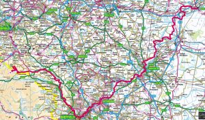
This is a proposed route following as closely as possible the course of the River Don in South Yorkshire (terminating at Goole which is in the East Riding). It would run in parallel with the proposed River Don cycling Trail.
There is no overall long distance Don Valley Way and we think there ought to be one similar to the Trent Valley Way and the Derwent Valley Way.
Start at Winscar Reservoir/Dunford Bridge. (SE 15482 02480)Cyclists could access the route by train to Penistone, cycle west on the TPT to get to the start. then retrace their route Easwards. It might be possible to access the source of the Don on rough tracks
https://osmaps.ordnancesurvey.co.uk/route/1676331/River-Don-Cycle-Trail
The route needs development as follows
- All in order Dunford Bridge to Rotherham.
- No Right of Way for cycles Rotherham to Aldwarke
- Aldwarke to Mexborough section needs riding to confirm
- All in order Mexborough to Barnby Dun
- The section from Barnby Dun to Goole needs riding to confirm especially along the Dutch River section.
The proposed DVW route coincides with other designated routes, eg The Pennine Trail, the Five Weirs Walk. NCN62 & 627 – but in order to stay as close as possible to the river we come off designated cycle routes occasionally and go onto minor roads
NB this is a cycling route to run in parallel with a walking route
Where does it go?
The ride starts on the Eastern side of the Pennines about 6 miles east of Pensitone. It finishes at Goole. (SE 15757 02350) The landscape is varied starting on the moors and ending in the E Yorkshire fens.
It goes through the following local authorities: Barnsley, Sheffield, Rotherham, Doncaster, East Yorkshire. The number of parishes needs researching.
It goes through the city of Sheffield and the major towns of Rotherham, Doncaster and Goole.
The terrain is both urban and rural with a great wealth of history and heritage in both the landscape and the sites along the route
How long is it?
The cycling route is 75 miles, which makes a day long-distance ride, but that would not leave much time for sightseeing – of which there are many opportunities.
The ride passes close to many railway stations.
It could be done in short and long sections and used as a recreational or leisure ride.
With such good public transport links there are many opportunities for getting to and from start and finish points for sections of the route and accommodation along the route.
People who live in the region could get to various start and from finish points from and to their own homes.
Elevation
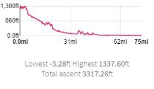
Note that this ride goes below sea level.